


The Mad Mapper
Here in the Bay of Plenty, I'm helping out a man by the name of John, who runs an organic dairy farm. In fact, this should be the first time since Christchurch that I end up on a WWOOFing place again - not intentionally, but rather because John advertises his place both on WWOOFing as well as HelpX.

But there's also a number of other people who are more or less part of the family. First of all is Zink aka "Sieg", a good friend of John and an Engineer who works on the farm machines...

...and then we have Luke aka "Stiggy", who is a 13-year-old kid from next door. Having issues with the public education system, he instead strives to make himself useful by helping out on John's farm, showing great initiative and a practical mindset - even though he can be a bit of a goofball sometimes.

His energetic, 6-year-old half-sibling Harry also regularly drops by, and although the two of them are not related to John, they still very much feel like a part of the family.

Finally, about a week into my stay, Eva - a WWOOFer from Germany - joins us. Unlike me, she has more or less made herself at home at John's farm, frequently returning to this place. As such she, too has become a part of John's extended family.

With this cast of characters introduced, let us now proceed to have a better look at...
The Place
WWOOFing places come in three sizes: House-sized, block-sized, and mega-freaking HUGE! With 130 hectares, John's farm is only the second-biggest place I've been to after the Island Hills Station (see Chapter 10 ~ The Island Hills Miracle). As such, giving you a full tour of the place is all but impossible, but I can at least show you the main house, as well as a number of areas I visit while riding on the back of John's tractor on the way to and from work.
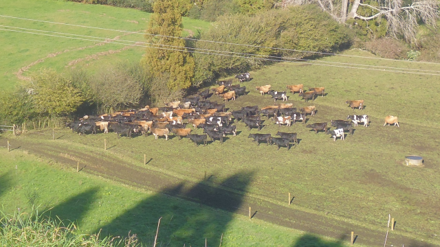
As an organic dairy farm, the main livestock are naturally female cows, as well as a small number of bulls.

Apart from the 23 dozen heads of cattle, there's also a significantly smaller number of horses...

...a brood of chickens...

...the lovable-but-suicidal dog Bella, who has the habit of trying to chase away evil cars by standing in the middle of the road, barking at them...

...and finally also a single goat kid, who makes his home in the pasture across the street.

Owing partly to its extensive nature, there are more beautiful places to be discovered on this farm than I can recount, from serene glades, to sprawling fields, valleys opening up all the way to the sea, rustic sheds, and the odd hidden clearing in a gully... it all adds up to one marvellous place to live in.

However, with the sea to the north, the most amazing views can be witnessed during the twilight hours...

...be it during a solemn sunset...

...or a spectacular sunrise.
However, since it is winter over here, we also do get our fair share of rainy and stormy days, and even though we're at Sicilian latitudes, the temperatures are rather frigid - especially at night...

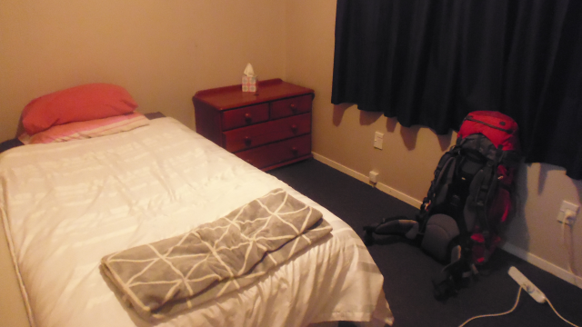
...which is why I'm quite grateful that I have a personal heating unit in my little cabin - even if it's only a Heaty-Puff Jr.

However, after every rain, there's sunshine, and as the clouds retreat, rainbows garb the land into a veil of prismatic colours.

Fortunately, we get a good amount of sunny (or at the very least reasonably dry) days, which is quite important, since the majority of the work here is quite outdoor-sy, which brings us to the next part:
The Job
There's quite a lot to do on the farm, and although most of it is at least indirectly related to the 280 cows, not every tasks involves working with the animals. On the very first day, for example, we drive out all the way to Te Kaha...

...to harvest a load of premium quality sea weed from a public beach.

The next day, we chop up the sea weed and put it into oversized tea bags, which in turn go into the cows' water troughs for them to enjoy some fine sea weed tea. In time, the mineral-rich brew will pass through the bovines' systems, and be organically distributed around the fields with little effort required on our part.

Next, one of the electric fences keeping the cattle in the paddocks is hopelessly overgrown, and as a result shorts out whenever it is activated. So John outfits me with heavy weed eating equipment...

...and over the course of two days, I manage to liberate the entire fence line of its brambly menace.

But yes, naturally being on a dairy farm means that I also get to work directly with the cows, doing things like shifting them from one pasture to another with fresh, green grass...
...or temporarily penning them up for a cow census.

Naturally, all of these cows also need to be fed, and with grass growth being slow during the winter months, we need to supplement their diet with hay. And thus, I often get to accompany John on the trailer of his tractor, distributing the hay across the paddock as he drives around.

And then on one occasion, we reverse the roles, leaving me to drive the big tractor around with John on the trailer distributing the hay.

As calving season arrives, it starts getting busy on the farm as new calves arrive. Unfortunately, not all of the bovines survive childbirth…

…which is one of the reasons why we go out in the middle of the night to check on the cows as we hear an anguished bellow from the herd. But fortunately, everything’s alright, and we even get to witness the first shaky steps of a newly born calf on this earth.
One of the tasks which is not in any way related to cows is the work in the kiwi fruit orchard, which John has recently acquired. There's a whole lot of pruned wood to gather up - in the process of which each of us, including Luke, gets to ride the cutie-little-tractor through the low-clearance trellises...

...followed by the arduous task of systematically tying down the kiwi fruit tree branches to the trellises.

By the way, the tractors are not the only vehicles I get to drive around the farm. There's also a sturdy old Mitsubishi Triton pickup truck...

...as well as a Suzuki DR 200 light motorcycle to make getting around the property easier. This makes this the first time I've driven a car on the North Island, and the first time I've driven a motorcycle in New Zealand. Much to my delight I learn that unlike cars - which are effectively mirrored, not only having the steering wheel on the other side, but also the levers for the indicators and windshield wipers swapped - motorcycles are identical in construction, making them significantly easier to adapt to.

However, the single one task that should make this stay different from all others (and keep me occupied for well than over half my stay), is creating a detailed map for the 130 hectare big map. An ambitious task, which should soon enough have me walk around the fields, checking every single fence line of the 106 pastures, and marking down every gate, every trough, and every geographic feature. If you think that in the age of satellite imagery, all of these tasks could be taken care of from the comfort of one's office, think again! Surprisingly even at the highest possible resolution it is tricky to make out wire-fences from space, and even more difficult to distinguish the gate-wires from the stationary ones. On top of that, brooks and fences look pretty much identical, and naturally following the fence line underneath tree cover is outright impossible. As such, the best I can do is make a rough draft, print it out, and then take to the fields armed with a clip-board and several pens to gather the data I need to make a great map, and while I can cover a part of the distance on motorized vehicles, the vast majority of the time I am still walking around on foot.

Interestingly, something stirs within me as I go about this lengthy task. At some level, I find this work deeply appealing and satisfying, much like creating games and worlds, and I know that now, after ten months on the road, I have finally found one of the shadows of myself standing at the end of a road I did not take. As a result I end up spending way more than the required 4 hours a day on this task, and often keep on surveying the fields until the daylight fails, wanting to continue for as long as possible, so that I might finish this amazing map for John.

Eventually, the end of my stay approaches, and while I'm making great progress on the map, time nonetheless eludes me, forcing me to take my chances on less-than-savoury days. On one such day, I get caught in a light rain shower, and while this is something that would not deter me as a person, the paper onto which I draw my observations is another matter entirely - and so I am left with no choice but to take shelter in a nearby shed, and sit out the rain...

...while watching a flock of Pukekos foraging the wet fields for food.
Eventually, however, after over 70 hours of dedicated work, the map is finally finished, and I can proudly say that it is the best map I've ever created.

But that's not all! I also create a second map for the Runoff, which is another property of John's a few kilometres away, on the other end of the Old Creamery Road, along the aptly named Crooked Road. However, since I don't have the time to properly survey this second property as well, this second map is not nearly as detailed as the one of the main property.

John is very impressed by this work, and honours all the extra hours I put into creating the map with my very first actual pay check, telling me to put the money into my travel funds. This makes this the third time during my travels that I actually get paid for my work, making me very happy. Now I just have to figure out how to work this check-thingie. Oh well, I suppose the people at the bank will be able to tell me.

With that, I can now officially say that I've found my favourite work in New Zealand, and do not expect to enjoy any task after this quite as much. Oh well, since I've only got two more places to go to, I suppose that's alright. But for now, it's time for an...
Interlude: The Woodland Whirl
Once again, I am graced with wheels - whether that be thanks to good fortune, or the fact that I'm actively seeking hosts which advertise free bikes. This time, however, the bike seems to have been selected especially for me.

Astride my Fox-Bike, I go on a ride that should take me down the Old Creamery Road and its extension, Crooked Road. Afterwards, I would travel down the Woodlands Road to Hukutaia Domain, before stopping by Opotiki, the beach, and finally returning back to John's farm up the Paerata Ridge.

The Old Creamery Road is an unsealed country road which start not far from John's farm. In fact, I've already come this way several times with John on our way to the Runoff, but going down the gravelly path by bike is quite different - and going up again on the other side of the valley it traverses is quite a strenuous experience indeed.

However, the view of the surrounding valleys I get in return is fantastic, and I'm not even on the road for half an hour.

The next part of my ride takes me up the Woodlands road, and almost all the way to the Kahikatea Range.

My target here is the Hukutaia Domain, which must be one of three places in the world using the "Historic Burial Tree" sign.

The Domain itself is a lush green forest with a number of walkways through the unforgettable nostalgic greenery, and so I dismount from my Fox-Bike, and go for a short stroll through the woodlands...

...which is also notably smoke free.

The main attraction here is - naturally - aforementioned historic burial tree. Also known as Taketakerau - which might be translated as "Ancient Gathering Place" - this 2000-year-old tree is "He Wahi Tapu Tenei No Mua", a prohibited place of olden times. Māori tribes would often gather the bones of their most venerated ancestors and put them into caves or hollow trees such as this one to prevent them from being stolen and defiled by rivalling tribes. This particular tree was used by the Upokorehe Hapu of the Whakatohea Tribe, and is held in high regards up to the present day, guarded by statues known as Teko Teko.

After this little excursion into Māori history, I travel back north towards the coast. Fortunately, that means I'm going mostly downhill, and before I know it, I've reached the single one bridge crossing the great Waioeka River. Attentive readers of my blog may have noticed by now that a lot of place, lake and river names start with "Wai", such as Waipukurau, Waipaoa, Wairarapa or Waioeka, and there's a logical explanation for that: In the Māori language, the word "Wai" simply means "Water", and can describe any body of water, be it a river, lake or swamp. As a result, the vast majority of lakes and rivers, as well as places related to them, start with "Wai", not unlike most lake names in the English language start with "Lake".

After crossing the bridge, I have officially entered the town of Opotiki...

...where I come across some spectacular, yet culturally less significant trees.

After a little side trip to the southern outskirts of town, I cycle back north along the Otara Stop Bank Trail, which has a very creative mechanism to force cyclists to slow down.

Figuring this one out takes me a few moments: You have to dismount and push your bike through the narrow central part while walking through either the left or right wing. It's an ingenious mechanism, since it's effectively impossible to traverse without actually dismounting.
As the name suggests, this trail runs atop the stop bank of the Orata, which marks the northeastern border of Opotiki.

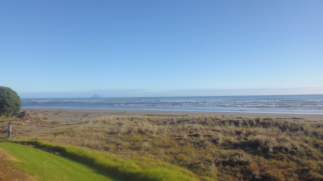
Crossing back over the Waioeka River, I make my way up the shore to Waiotahe Beach only half an hour away from sunset...

...where I unexpectedly find myself being chased around by the playful waves of the Pacific Ocean as I take in the panorama.
In the distance, the sun can be setting just a short distance away from Moutohora Island, which is located across from the 20km distant town of Whakatane, which in turn should become a place of relevance before long.

I would love to stay and watch the sunset, but unfortunately, this beach is a good 5km away from John's farm along an unlit and steep road, and my Fox-Bike unfortunately does not come equipped with a light. So I soon make my way up the Paerata Ridge Road and through the green canyons of hedges bordering the countless kiwi fruit orchards in these parts just as the final rays of sunlight disappear behind the western horizon.

Although nowhere near the dimensions of my full-day rides in places starting with "G", this excursion has nonetheless made me quite hungry, which makes it all the more fitting that I should return just in time for...
The Food
Days here at the farm routinely start with a bowl of porridge with raisins, as well as a cup of green tea. Or was that a green cup of tea? I forget.

Lunchtime easily doubles this variety by alternating between bacon and eggs, or toasts with chutney.

And for the evenings, John’s favourite recipe is a hearty boilup made from home-grown beef, watercress and kumara…

…but there’s also a number of other dishes, such as pumpkin soup, sausages, rice soup or risotto.

On two nights, however, we drive out all the way to Whakatane in the evening…
On our first visit to this touristy town, we dine in an Indian restaurant aptly named the Spice Junction, where I lavish myself with medium-hot Wild Goat Curry…

…while the other time we originally come to eat sushi, but default back to Indian cuisine once we learn that our intended sushi bar is closed for no reason in particular. This time I have the Popsies Special Medium Lamb Curry, along with some Cheese & Garlic Naan Bread.

Delicious though these curry dishes might be, they naturally can’t beat my legendary tri-Tail pizza. This time around, I even have a willing helper in the guise of Harry, who assists me in grating the cheese…

…and as a reward gets to play Freedom Planet on Liete.

Naturally, everyone is absolutely delighted by my amazing pizza…

…so much that they are more than happy to let me do the cooking on a number of nights after that. Hence, I end up cooking a number of savoury recipes for them, such as Naleiayafero, Gamm Ligeral and Rahmschwammerlngeschnetzeltes.

And on top of all of that not only do I get a virtually unlimited amount of almonds and cashews to snack on…

…my efforts are also rewarded with the ice tea which is so dear to me.

With all this tasty food, I am soon revitalized, and ready for…
Interlude: The Waipututawa Walk
This next stray should be a bit different from my usual ones. How so? Well, while I normally undertake my explorations on my own, this time around it’s a trip on which John invites all of us.

We start out with a short drive into the mountains, from where we would eventually ascend from about 180m to the Waipututawa peak at 552m.

The ascent starts with a simple enough forest path, and although all of us are experienced hikers, it does not take me long to leave the others behind me.

Solely young Harry seems to have the energy to keep up with me, and soon enough the others vanish from view behind us as we scale the mountain at our own pace.

This is actually Harry’s first time wandering, so the boy is really excited about it. Little do we yet realize that this trip should soon become even more adventurous as nonsensical amounts of fallen trees bar our path forward.

However, we don’t let that stop us. Climbing over branches, ducking through tunnels of twigs, and circumnavigating roots, Harry and I eventually make our way to the very top…

…from where we get an amazing panoramic view of the Bay of Plenty below.

We can even see all the way to Whakaari in the distance. This island, also known as White Island, is an active andesite stratovolcano, situated 48 km from the coast of Opotiki.Rising up 321m above sea level and about 1,600m from the sea floor, this island has continuously built up over the last 150,000 years. That's over a centimetre per year! It is New Zealand’s most active volcano and has been in a continuous state of at least smoking since the beginning of human observation, with its last eruption having been on the 20th of August 2013.

It doesn’t take the others too long to catch up with us…

…and after a short break to enjoy the scenery and gather our strength, we start making our way down the forest path again… or rather, making our way down next to the forest path, which proves to be significantly easier than climbing over all those trees again.

Once again, Harry and I are the first ones down, taking a break and relaxing while waiting for the others to catch up with us five minutes later.

I’m impressed with how Harry was able to keep up with me all this time, and can’t help but remember the mountaineering trips I did with my grandparents when I was young. Meanwhile, Luke is quite overheated after all this exercise and briefly thinks about jumping into a nearby stream to cool off, but quickly reconsiders after sampling the frigidly cold waters.

That marks the end of this particular trip. Which makes now the time to tell you a bit about…
The Flair
Like so many other places, the Bay of Plenty also has its fair share of curiosities, which are easily discovered if you keep your eyes peeled. Let us start with the fact that one evening, I mysteriously manage to get side-tracked all the way to…

…and beware the bay home kills, which are protected by high-speed wireless devices.

Next, there’s this little orchard which has had a great idea for making good use of old drums…

…and a school in Opotiki that had the great idea of making use of an empty façade, and turning it into an anti-drug campaign with the help of creative students.

Also introducing a new and amazing invention: The solar street lamp!

Back on the farm, there are some troughs which have probiotically remodelled themselves into perfect algae biotopes…

…and here’s a pair of stoic lawn-guardians standing watch over a house just down the road.

This little shack has certainly seen better times…

…unlike this streamlined family home from the 21st century.

Also, I guess this is what you’d call a wedge of cows.
Watch out, brave bovines, because…

With that being taken care of, let us now continue to our next trip, namely…
Interlude: The Ohiwa Outing
My second solo stray in this area should take me down the Paerata Ridge to Waiotahe Beach, where I ended my last ride, then west along the coast up to Ohiwa, and then south along the coast of Ohiwa Harbour, before bringing me back to John’s Farm via a number of back country roads.

This excursion starts the same way the last one ended: By taking me through the green canyons of kiwi fruit orchard hedges. Only this time, it’s dawn instead of dusk.

And then, it’s west along the coast of the Bay of Plenty.
Once again, I traverse a river on my way, but this time, it’s the Waiotahe River, after which Waiotahe Beach is named.

Since the tide is just in the process of rushing out, the extensive Waiotahe Estuary is slowly drying up, and sea birds are beginning to congregate in order to forage for food.

The Onekawa trail which follows should prove to be a slight obstacle, since the stairs are a tid-bit tricky to navigate by bike. So I end up pushing my Fox-Bike up the hill from sea level to the peak of 103m…

…however, I am once again rewarded with an amazing panoramic view of the surrounding area, featuring the entirety of Ohiwa Harbour and port Ohope at the other side of the inlet.
Up here, cute Piwakawakas grace me with their presence once again, and I am now certain that of all the unique fauna of New Zealands, it’s these little aerial acrobats that I will miss the most.

The path down leads through similarly bike-unfriendly bush, but fortunately down is always easier than up, and soon enough I’m back at sea level again, at the outskirts of the little village of Ohiwa.

Cycling down the coastal road, I eventually come by a colony of peculiar phone-call birds, the likes of which I have not heard before.
Finally, I reach the western limit of my ride near what I’d personally call Foxtail Peninsula, and start making my way south along the shore of Ohiwa Harbour.

The way back east demonstrates a perfect example of New Zealand road design. Why go through all the effort of building a road around the hill if we can just cut straight through it? I mean, it’s not like we live in earthquake territory or something, right?

Unlike the Waioeka River, the Waiotahe River actually has a number of bridges leading across it, and so I traverse the river a good distance further upstream on my way back.

The final distance across the valley leads me along the aptly named Brown Road…

…and then it’s up the final climb onto the Paerata Ridge. Although it’s barely 400m long, it’s steep incline make me glad that my Fox-Bike has excellent gears to help me conquer this last hurrah.

After that, it’s easy going along the ridge road, beautiful view included. And after working up quite a sweat on my way up here despite the cool winter temperatures, I’m quite glad for the little bit of shade.

With that, my second solo stray comes to a close. I had originally planned to do it as one big stray, but right now, my legs are quite glad that I decided to split it up into two separate ones. And speaking of looking back, it’s now time for…
The Retrospective
Once again, I get to look back on a great place. Granted, the accommodation was a bit sub-standard, but at least the Heaty-Puff Jr. kept my cabin reasonably warm despite the cold nights and the fact that it was about as thoroughly insulated as your average pin cushion. As for the facilities… they were not great, but still acceptable.
That being said, let us now proceed to the things I really enjoyed about this place. The atmosphere was good, I was granted a bike to explore the area with, and we even went on a mountain trip together. As for catering, this was the first place ever where my host took me out to dine in a restaurant not only once but twice, and I was also lavished with ice tea, chips and other snacks, so that certainly leaves nothing to be desired in that category.
The very best thing, however, was that this was the very first place where I found a task so immersing and motivating that I voluntarily worked hours without expecting any kind of compensation for it. Granted, I’ve made maps before, but this place was the first place where my host was willing to let me spend the majority of my work time on it, and I really, truly enjoyed myself being out there in the fields, surveying the extensive farm, and later translating my observations into a digital form which should serve John for years to come. In fact, this makes this the first place to earn ★★★★★ in the “Work” category in my book, and with only two more places to go is quite possible the one and only to achieve that feat. A regrettable side effect of my enthusiasm, however, was that the work-value ratio suffered a little bit, but oh well. I certainly didn’t mind.

Naturally, I’m happy enough to prepare the traditional piece of gift artwork for him, and since they all seem like one big happy family to me, I decide to include Zink, Luke, Harry and Eva as well. As usual, they are delighted to receive this little token of my gratitude, and John declares he’s going to have it framed and put on a wall.

And with all of that being said, it is now time to look forward to…
The Road Ahead
Circumstances should have it that my departure was to be one day delayed due to road closures, however, the day of my departure inevitably arrives in the end, and so John and Eva drop me off at the bus station in Opotiki, where the bus is already waiting.

My next destination is Cambridge, which is the furthest from the sea I’ve been since Carterton. It’s also a measly 20km away from Hamilton, through which I passed on my way from Auckland to Oakura many months ago. As thus, my journey around the North Island is now almost, yet not quite complete.

The way there takes me along the coastal road through Ohope and to Whakatane – which so far I only know by night – and then inlands into the Whakapoungakau Range. Subsequently we pass by a tetrad of Roto-lakes (Rotoma, Rotoehu, Rotoiti and Rotorua, “Roto” meaning “Lake” in Māori), before stopping for a lunch break in the town of Rotorua. Afterwards, we continue through the relatively flat planes of the Mamaku Plateau, before entering the great Waikato River Valley, and finally arriving in Cambridge.
On our rest stop in Rotorua, we stop by a giant metal duck from the past…

…and I hurriedly hasten through the city in search of a place that sells humble pies, finally finding one just in time before the bus departs again.

Yet although I am only in town for about 20 minutes, I see quite a few curiosities, such as a Christmas tree made of bicycles, an inflatable fair, and a number of architectonically interesting constructions.

Speaking of interesting architecture, the town of Tirau – through which we pass about half an hour later – has a very interesting iSite and shop.

Another half an hour later, I arrive in Cambridge, where the bus drops me off at the stop just outside the town hall.

I don’t have to wait long for my next host to pick me up from here, and take me to my next home in the suburb of Leamington.

Here, I once again have a room in the actual house, which I find very nice already.
And after I have settled in, it’s already time to start helping out. But that’s a story for another time. So stay tuned for more Tales from the Travelling Fox!
No comments:
Post a Comment